
Where is Hardoi district, Hardoi population 2025, Hardoi area in sq km
Where is Hardoi: Hardoi is a district of Uttar Pradesh state in India. Hardoi district is located in the northern part of the country and comes under the Lucknow division. Headquarter of Hardoi district is in Hardoi city. The population of Hardoi district in 2025 is around 47 lakh people. Hardoi district has a total area of about 5,947 square kilometers. The vehicle registration (RTO) code of Hardoi district is UP-30. The main languages spoken in Hardoi district are Hindi, Urdu, and Awadhi. Hardoi district is known for farming and local culture. Where is Hardoi, Hardoi population 2025, Hardoi area in sq km.
| Hardoi State name | Uttar Pradesh |
| Hardoi district headquarters (City) | Hardoi |
| Hardoi Pin Code | 241001 (Hardoi city) |
| Hardoi area in sq km | Approx. 5,947 sq. km |
| Hardoi population 2025 (full district) | Around 47 lakh |
| Hardoi RTO code | UP 30 |
| Hardoi local language | Hindi, Urdu |
| Nearest Airport to Hardoi | Chaudhary Charan Singh International Airport, Lucknow (approx. 120 km) |
| Major Cities/Towns | Hardoi, Sandila, Bilgram, Shahabad, Mallawan |
| Tehsils and Sub-Tehsils | Hardoi, Sandila, Bilgram, Shahabad, Mallawan, Sawayajpur, Pihani, Sandi |
| Hardoi DM Name | Mr. Anunaya Jha |
| Hardoi DM office address | DM Office,Collectorate Hardoi 241001 |
| Hardoi Official Website | hardoi.nic.in |
The main geographical features of Hardoi include a mix of flat and elevated land. The soil here is fertile, allowing for the cultivation of crops such as rice, sugarcane, and maize. Additionally, several rivers flow through Hardoi, which are crucial for agriculture. While industrial development in the district is limited, there are sugar mills and some small-scale industries present.
Culturally, Hardoi is diverse. The primary language spoken is Hindi, particularly among the Kannauji-speaking population. The district consists of five tehsils: Hardoi, Shahabad, Sawaijpur, Bilgram, and Sandila. Hardoi also boasts several historical sites like Prahlad Ghat and Sandila Bird Sanctuary that attract tourists.
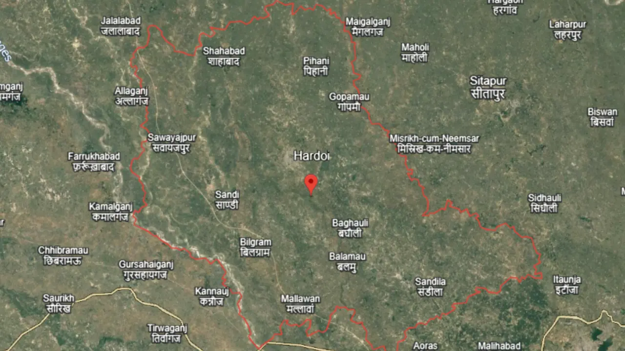
In terms of social structure, Scheduled Castes make up a significant portion of the population at 31.14%. The literacy rate in Hardoi is about 64.6%, with a sex ratio of 868 females for every 1,000 males. Thus, Hardoi is not only an agricultural hub but also has a rich cultural and historical heritage, What is Hardoi, Where is Hardoi located in red circle.
The history of Hardoi is rich and diverse, stretching from ancient myths to the British colonial period. Originally named “Haridrohi,” meaning “enemy of God,” it is linked to the demon king Hiranyakashyap. He tried to stop his son Prahlad from worshipping Lord Vishnu, which led to Lord Narasimha killing him. This event holds great significance in local culture and is celebrated during the festival of Holi.
During the medieval period, Hardoi saw many battles between Mughal and Afghan rulers. In 1028 AD, Syed Salar Masood Ghazi invaded the area, but it wasn’t until 1217 AD that Muslims established permanent control, What is Hardoi, Where is Hardoi located in red circle.
The British established Hardoi district on October 28, 1859. Initially located in Mallawan, it was formed under District Magistrate W.S. Chaper. The region witnessed significant events during the 1857 freedom struggle, including clashes between local freedom fighters and the East India Company.
Hardoi’s history is not just filled with myths and wars; it also played a crucial role in India’s fight for independence. Mahatma Gandhi held a public meeting here in 1929, highlighting the area’s political awakening.
Why is Hardoi very famous
Hardoi is an important district located in Uttar Pradesh, India, known for its rich history and culture. This area is recognized mainly for its agricultural production and religious sites. Historical texts from ancient times reference Hardoi, highlighting its significance. The soil in this region is very fertile, making it famous for crops like wheat, rice, and sugarcane. Additionally, Hardoi is known for its religious places, including the Sandi Bird Sanctuary, historical temples, and various fairs. The Sandi Bird Sanctuary attracts many bird lovers as it hosts numerous migratory birds. Along with its historical and cultural heritage, Hardoi has connections to the Indian independence movement, adding to its pride and significance.
What is famous to eat in Hardoi
Haridwar is a well-known city in Uttar Pradesh, famous for its delicious food. The pedas from Itouli are particularly renowned; these sweets are made from khoya and sold in long-established sweet shops near the Itouli bridge. Their taste is so delightful that people travel from far and wide to enjoy them.
Another popular dish is the aloo tikki, especially found at Babu Lal Chaat Bhandar in Kachhouna. Here, the tikki is served with nuts and a special chutney, enhancing its flavor.
Roasted potatoes are also a local specialty, available from Rajkumar’s stall at Railwayganj Chowk. These potatoes are served with a unique chutney that makes them even more tasty.
Lastly, Anna Dosa, a South Indian dish, is quite popular among the locals. It is sold by S Pandi, who came from Madurai, and includes various types like masala dosa, butter masala dosa, and paneer masala dosa, What is Hardoi, Where is Hardoi located in red circle.
Which are the neighboring districts of Hardoi
Hardoi district is located in the central part of Uttar Pradesh, India. It is surrounded by several neighboring districts. To the north, there is Shahjahanpur district, which is about 36 kilometers away. In the east, you will find Sitapur district, approximately 50 kilometers from Hardoi. To the south, the districts of Lucknow and Unnao are situated at distances of around 110 kilometers and 80 kilometers, respectively. Finally, to the west, you can reach Kannauj and Farrukhabad districts, located about 70 kilometers and 90 kilometers away from Hardoi.
Are there airports in Hardoi or not
Currently, there is no airport in Hardoi. However, the nearest airport is Chaudhary Charan Singh International Airport located in Amausi, Lucknow, which is approximately 119 kilometers away from Hardoi.
What are the main tourist destinations of Hardoi
Haridwar is an important district in Uttar Pradesh, known for its religious sites and historical heritage. Here are some key tourist attractions:
- Baba Temple: One of the ancient temples in Haridwar, located near Prahlad Ghat, built in 1949, featuring several deities.
- Prahlad Ghat: A sacred site housing the idol of Lord Narasimha, with a pond surrounded by steps.
- Sandi Bird Sanctuary: Established in 1990, this sanctuary spans 309 square kilometers and is a winter home for migratory birds, located about 19 kilometers from Haridwar.
- Nawab Diler Khan’s Tomb: Situated in the Sharabad tehsil, this tomb is protected by the Archaeological Department and features a grand pond.
- Raja Narpat Singh Memorial: Located near Madhauganj, this memorial honors freedom fighter Raja Narpat Singh and includes beautiful gardens and pavilions.
- Shiv Sankat Haran Temple: About 20 kilometers from Haridwar city, this temple is famous for helping devotees overcome their troubles and has a large Shiva lingam.
- Aastik Muni Maharaj Temple: This approximately 300-year-old religious site was recently designated as a tourist destination by the government, believed to fulfill devotees’ wishes.
FAQs
In Hardoi, the main languages spoken are Awadhi, Bhojpuri, and Kannauji. Awadhi is primarily spoken in areas like Lucknow, Raebareli, and Sultanpur. Bhojpuri is common in the Gorakhpur and Basti regions. Kannauji is used in the areas surrounding Hardoi and is an integral part of the local culture.
The area of Hardoi is approximately 3,254 square kilometers. It is located in the Lucknow division of Uttar Pradesh and consists of five tehsils. The geographical position of Hardoi makes it significant for agriculture and rural development, What is Hardoi, Where is Hardoi located in red circle.